A Frankenstein Atlas: RationalE
Mary Shelley’s (née Godwin) Frankenstein is a profoundly geographical text. The novel opens with an epistolary exchange between St. Petersburg and London and, from there, it takes readers on a peregrination back-and-forth across Northern Europe and the circumpolar north. The book’s characters expand the text’s geographic boundaries by imagining lands and peoples in the Americas, Asia, and the Pacific. The ways in which Shelley describes these places is essential not only to the narrative but also to our understanding of the novel’s fundamental themes. Given this rich geographical framework, Frankenstein offers teachers a valuable tool with which to explore the historical, geographical, and literary worlds of the late eighteenth and early nineteenth centuries.
An open access project created at IUPUI in 2017-2018 in response to the 200th anniversary of the book’s publication, A Frankenstein Atlas is deeply influenced by the theories and practices associated with the spatial humanities—especially literary mapping, deep mapping, and humanities GIS. This project brings together students and researchers to build a collaborative literary and historical open access atlas of Mary Shelley’s Frankenstein. As a pedagogical experiment, “A Frankenstein Atlas” helps teachers and students explore the rich spatial imaginary of Frankenstein [1] while teaching students basic skills in digital humanities and literary and historical analysis. It highlights how the digital humanities can be employed effectively to teach students about the theoretical and methodological challenges inherent to text analysis and research, using both traditional and digital methodologies. The design of the project and its analytical approach provide a model for how other similar projects might be implemented in the classroom.
Defining Geographical Locations
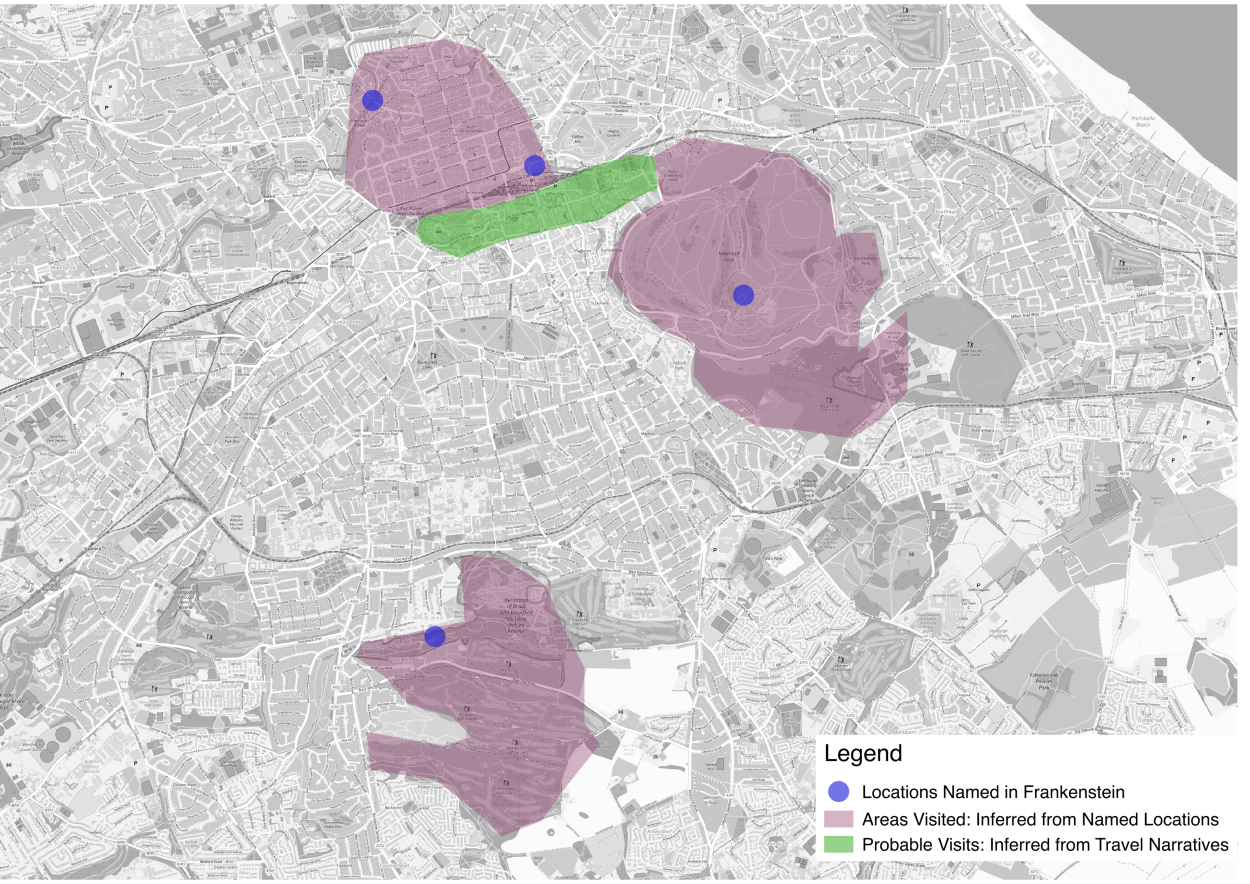
Frankenstein and Clerval's Visit to Edinburgh in Frankenstein
One of the difficulties in developing a literary geography of Frankenstein is the fact that there are relatively few geographical specifics noted in the text. Even when Shelly mentions a specific location, its position in space might still be relatively general. For example, she writes of Frankenstein and Clerval's visit to Edinburgh and the surrounding regions:
I visited Edinburgh with languid eyes and mind; and yet that city might have interested the most unfortunate being. Clerval did not like it so well as Oxford, for the antiquity of the latter city was more pleasing to him. But the beauty and regularity of the new town of Edinburgh, its romantic castle and its environs, the most delightful in the world, Arthur's Seat, St. Bernard's Well, and the Pentland Hills compensated him for the change and filled him with cheerfulness and admiration.
Are we to assume that the locations she mentions in the text are the only ones Victor and Clerval visited? Or, might we infer that in addition to visiting New Town, they also toured explored Old Town?
When it comes to using Frankenstein as a pedagogical tool, these questions are quite productive. They encourage us to ask numerous questions. How might we map the Edinburgh of Frankenstein? Is it a point? Is it in an area? How did Frankenstein and Clerval move through the space of the city? Is it possible to map the roads that they likely traveled to get from place to place? How is translating Shelley's mental map of Edinburgh into a map based on geographical coordinate an interpretive choice? To what extent does our knowledge of geography make a difference in our understanding of Frankenstein? What might the locations that she mention mean to Shelley? What might they have meant to her readers? How does Shelley constructed Edinburgh as a place, not just a geographical space? In class, we found that asking these questions was quite productive. And, in fact, it was this approach that drove the development of our prototype "deep map" locations, which we are integrating into the Gazetteer.
To get a better sense of the conversations that we had about the geography of Frankenstein, see this short essay on the polar regions in Frankenstein.
[1] By “spatial imaginary,” I follow the definition of Alison Blunt and Robyn Dowling: “a set of intersecting and variable ideas and feelings, which are related to context and which construct places, extend across spaces and scales, and connect places” in Alison Blunt and Robyn Dowling, Home (New York: Routledge, 2006), 2.